
Please send in your results asap. Download HERE.
And then send in your reports with all the pictures, stories, lies, truths that you can muster.
Traditionally, we have a presentation lunch near the end of November but this year I helping Anthony Smith with his RAFT!! Click HERE
The container leaves on 11th and we fly out to meet it on Montgolfier Day.
So what do people think? Since I have only received 2 results so far and one report, I wonder if there's time to arrange something before I leave?
Thoughts please to robin@gasballoon.com
Thanks,
Robin.
Sunday, 7 November 2010
Sunday, 31 October 2010
Day 31 - cloudy with rain
Cloudy with rain at times for much of England and Wales, with perhaps a few brighter intervals at times in an easterly breeze. Dry in Northern Ireland and Scotland however, after morning fog clears, with Scotland seeing some bright periods.


Saturday, 30 October 2010
Day 30 - see below
Sunshine with occasional showers for most, particularly in western parts, with some perhaps turning thundery at times. More persistent rain and strong winds should arrive in the far southwest towards the evening, with gales in the far north easing later.


Friday, 29 October 2010
Day 29 - strong southerlies
Today looks set to see some very wet weather developing over parts of Ireland and western Scotland for a time and the risk of rain will spread to many areas during the day with south-eastern parts probably staying dry until dusk. This changeable and mild theme then continues through the weekend and into next week.


Thursday, 28 October 2010
Day 28 - wet & windy...again.
A deep area of low pressure passing close to northwest Britain today will bring some further wet weather to western parts as well as some strong winds. However, with the winds continuing to come in from a south or south-westerly direction it will remain on the mild side.
A waving cold front is lying across western districts today and will bring outbreaks of rain at times to many parts of Scotland, Ireland, Wales and western parts of England. The rain is likely to intensify as we go through the day, with some particularly heavy bursts expected over Ireland and southwest Scotland at times. Southwest Scotland is our main area of concern, and we have a Weather Watch out for the possibility of some very wet conditions developing here later on. Meanwhile, for much of the rest of England it will be a mostly dry day with some bright spells and just the odd shower around before some more persistent rain pushes in from the southwest later this afternoon. It will be windy in many areas again, but mild once more.
The rain continues to move northeast tonight, clearing most areas by the early hours of Saturday. Many places will then become clearer, but a scattering of showers can be expected around western and southern coasts. Saturday will then be a brighter day for many parts with sunny spells, but further showers are likely around windward coasts where they will be heavy at times. Later in the day, the next area of rain will push into the far southwest, and this rain will affect south-western areas on Saturday night, before extending to other southern districts on Sunday, although weakening by then. It will be drier and brighter towards the north though, and by Monday many places look like enjoying a dry and bright day before wet and windy weather arrives in the west later.

Wednesday, 27 October 2010
Day 27 - rain
Tuesday night was mild and windy night for many parts, with another band of rain coming in from the west. The rain will move east so that by early Wednesday it lies across southern and eastern areas with clearer spells and showers following elsewhere. The heaviest and most frequent of the showers will be towards northwest Scotland where it will be windy with a risk of gales. Once the rain leaves south-eastern areas on Wednesday morning, many places will be dry with some sunny spells. However, showers, sometimes heavy and prolonged, will affect many north-western regions and it will remain pretty windy.
The mild and unsettled theme then continues through to the end of the week, with some very wet and very windy weather likely towards the north and west at times whilst southern and eastern areas see the best of any drier and brighter weather.


The mild and unsettled theme then continues through to the end of the week, with some very wet and very windy weather likely towards the north and west at times whilst southern and eastern areas see the best of any drier and brighter weather.


Tuesday, 26 October 2010
Day 26 - rain and wind.
Cloudy with occasional rain and strong to gale force southwesterly winds. Some of the rain is likely to be heavy at times, especially in the north. Feeling less cold.


Monday, 25 October 2010
Day 25 - Frosty start. High pressure
Crisp, cold and frosty first thing with a few fog patches. Otherwise, mainly dry and sunny with light winds, but becoming cloudier in Northern Ireland and western Scotland with a chance of rain by evening.


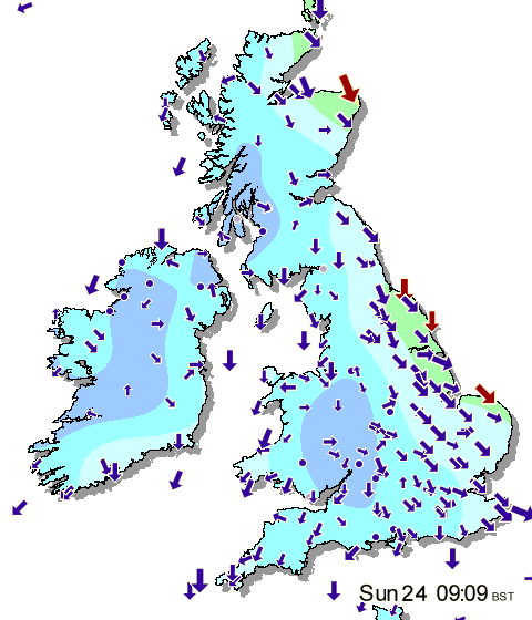
Sunday, 24 October 2010
Day 24 - frosty start
It is a cold and sunny start to the day across much of Britain and Ireland with a widespread frost to start the day for many. Eastern coastal districts have escaped the frost thanks to a northerly breeze and a few showers, and temperatures also remained a little higher around other coastal areas thanks to the relatively warm sea temperatures.
For the most part today will be fine and sunny if rather on the chilly side. The showers across eastern England and northeast Scotland will keep going for much of the time but even here there will be plenty of drier and sunnier spells in between. Temperatures will be a touch below normal despite the sunshine, and it will feel rather chilly when exposed to that northerly wind in the east.
Clear skies tonight will mean that temperatures will take a big fall and a widespread frost is expected for many parts. In rural spots this frost will become quite sharp, with minimums of -5C or below likely in some northern areas, and some patchy fog may well form too. The new working week will start off on a very cold note then, but it will be fine and sunny apart from the odd lingering shower close to the east coast. Many places will remain fine again on Monday, but later in the day freshening winds, thickening cloud and rain will arrive over Ireland.
This marks a change to a more unsettled outlook as we go through the coming week, but it will turn a milder. Rain will cross the country at times, accompanied by fresh to strong winds too, but with sunshine and showers in between.

Saturday, 23 October 2010
Day 23 - thundery showers in SE
Early rain clearing the far southeast before a day of sunshine and occasionally thundery showers for many. Drier than of late in Scotland. Feeling cold with winds becoming northerly.


Friday, 22 October 2010


Thursday, 21 October 2010
Day 21 - Frosty start
A frosty start over southern and central parts of the UK, with sunny periods and a few showers to follow, especially across Wales and southwest England. Outbreaks of rain are expected across parts of Scotland and Northern Ireland. Feeling milder.


Wednesday, 20 October 2010
Day 20 - cold northerlies. Good for channel flight?
Today will start off cold and sunny for many, with showers continuing to affect windward coasts. Most of the showers will become confined to the far east of England by the end of the day with many places staying fine and dry. However, cloud and showery rain - with snow over the hills - will be moving into northwest Scotland later on Wednesday, with this spreading to other areas on Thursday and Friday before some potentially very unsettled conditions develop over the weekend.


Tuesday, 19 October 2010
Day 19 - Bright start with showers later.
Beginning bright and sunny inland with showers over exposed northern and western coasts. The showers, sometimes heavy and wintry in the north, affect most parts during the day. Windy and feeling cold.


Monday, 18 October 2010
Day 18 - Wet in Scotland, drier & brighter elsewhere.
Showers will affect Scotland throughout the day, becoming persistent in some parts by the afternoon. Drier and brighter at first in other parts of the United Kingdom but with outbreaks of rain spreading from the northwest. Windy in the north.


Sunday, 17 October 2010
Day 17 - Colder
Sunday dawns fine and chilly across many areas and will then be a fine and sunny day across much of England and Wales. Scotland and Ireland will be cloudier with some showery rain around, which will spread into northwest England by late afternoon. The cloud and showers are associated with a weather front that will move across the rest of the country during Sunday night and Monday, introducing a colder north-westerly wind which will bring a mixture of sunny spells and blustery showers to many areas. Some southern parts will stay mainly dry whilst the showers across the mountains of Scotland will begin to turn increasingly wintry by Tuesday.
Happy landings to One Man Meet Pilots.


Happy landings to One Man Meet Pilots.


Saturday, 16 October 2010
Day 16 - Dry & bright, breezy in SE.
Today will start off dry and bright with sunny spells for many, and whilst this pattern will continue for much of the day, there will be a few showers affecting eastern areas as the winds go north-easterly for a time. A cold night is expected tonight with clear skies and light winds for many, but cloudier weather will move into the northwest, bringing a little rain with it. This cloud and rain will spread south-eastwards on Sunday, but much of southern Britain should enjoy a fine day before the cloud arrives by the evening.


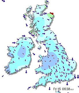
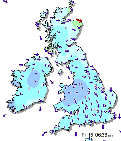
Friday, 15 October 2010
Day 15 - Scattered showers
Subtle changes today, as the northerly wind picks up a bit, bringing a band of showery rain southwards. The increase in wind will allow for a few more sunny spells to break through in between the showers although it will remain on the cool side. The weekend sees many areas having a dry day with some bright spells on Saturday, but with a few showers in the southeast, then by Sunday the winds will freshen up in the north, bringing rain with them, and that marks the start of the change that's expected next week.


Thursday, 14 October 2010
Day 14 - Cool northerlies
A dry, cool and cloudy day for the majority, with perhaps the odd spot of drizzle at times. The best sunny periods are likely towards the south of the UK, though perhaps some brightness too in southern Scotland later.


Wednesday, 13 October 2010
Day 13 - cooler & cloudier
Largely dry but cloudier and cool for many, with the best of any brightness across southwest England and Wales. Drizzle still possible in northern and eastern parts of the UK.
~ ~ ~
An area of high pressure is the dominating feature at the start of the period and this is expected to drift southwards as the week goes on.
This results in brisk easterly winds over southern areas gradually easing, while cloud amounts increase generally across the country as the weather system becomes slow-moving and gathers extra moisture.
Daytime temperatuers will gradually fall under this cloudy regime, but overnight frost and fog are only likely where cloud clears for any length of time.
High pressure is expected to finally give way at the end of the week and over the weekend, with stronger winds and outberaks of rain spreading south to all parts.


Tuesday, 12 October 2010
Day 12 - cooler & cloudier
Conditions remain mostly settled across Britain and Ireland today but there will be a lot more in the way of cloud around than there was yesterday making for a disappointingly cool day compared to recent days.
Cloud has spread in from the North Sea overnight across much of Scotland and England, with patchy mist and low cloud also to be found over parts of Wales and Ireland. The thickest of the cloud is across north-eastern areas where it is producing some patchy drizzle at times and this will continue on and off for much of the day. There are some sunny spells around however, mainly across southern and western areas, and these may become somewhat more widespread during the day with western areas enjoying a pleasant afternoon whilst it remains rather cloudy across eastern parts. Temperatures generally will be cooler than recently, especially under the cloud cover, but it will still feel quite warm in any sunny spells.
The cloud in the east will flood back west tonight, and will cover most areas by Wednesday morning with a generally misty and murky night developing. Some light rain and drizzle will also affect north-eastern areas too so it will end up rather damp here. Then for tomorrow it will be a dull start for many parts, and whilst many areas will remain cloudy, some sunny spells will again develop over some south-western areas. Very little then looks like changing through to the end of the week, so it will remain very quiet for several days yet.


Monday, 11 October 2010
Day 11 - breezy
Mostly dull to start with some fog, especially Northern Ireland. Clearer in southeast and locally the west. Cloud and fog clearing through the morning to leave a sunny afternoon for most, however the northeast remaining overcast. Breezy in the south.


The weekend saw temperatures reaching 22C in some sunnier parts of the UK, the result of warm air being drawn up from southern Europe at the end of the week.
Not all areas were so lucky. A dank, grey chill hung along many North Sea coasts of Scotland and England and with that cooler air poised to move southwards, lingering memories of summer warmth will be replaced by damp autumn coolness.
This results in brisk easterly winds over southern areas gradually easing, while cloud amounts increase generally across the country as the weather system becomes slow-moving and gathers extra moisture.
Daytime temperatuers will gradually fall under this cloudy regime, but overnight frost and fog are only likely where cloud clears for any length of time.
High pressure is expected to finally give way at the end of the week and over the weekend, with stronger winds and outberaks of rain spreading south to all parts.
By the end of the period, the generally changeable theme is expected to continue, with occasional rain or showers, but some drier and brighter intervals as well.
Daytime and overnight temperatures will be around or just below average by the end of the week. However, there is an increasing risk of ground frost across more southern and western parts later, especially given any clear skies overnight.
This is likely to swap round later in the period as the weather settles down in the north, while becoming more changeable further south with rain at times.
Temperatures will remain generally a little below average with a continuing risk of frost overnight.


The weekend saw temperatures reaching 22C in some sunnier parts of the UK, the result of warm air being drawn up from southern Europe at the end of the week.
Not all areas were so lucky. A dank, grey chill hung along many North Sea coasts of Scotland and England and with that cooler air poised to move southwards, lingering memories of summer warmth will be replaced by damp autumn coolness.
Monday 11 October 2010 to Sunday 17 October 2010
Cooler and cloudier
An area of high pressure is the dominating feature at the start of the period and this is expected to drift southwards as the week goes on.This results in brisk easterly winds over southern areas gradually easing, while cloud amounts increase generally across the country as the weather system becomes slow-moving and gathers extra moisture.
Daytime temperatuers will gradually fall under this cloudy regime, but overnight frost and fog are only likely where cloud clears for any length of time.
High pressure is expected to finally give way at the end of the week and over the weekend, with stronger winds and outberaks of rain spreading south to all parts.
Monday 18 October 2010 to Sunday 24 October 2010
Increasing chance of rain
The week is expected to start on a changeable note, especially for the north and east, with the best of the sunshine across the south and west.By the end of the period, the generally changeable theme is expected to continue, with occasional rain or showers, but some drier and brighter intervals as well.
Daytime and overnight temperatures will be around or just below average by the end of the week. However, there is an increasing risk of ground frost across more southern and western parts later, especially given any clear skies overnight.
Monday 25 October 2010 to Saturday 6 November 2010
Unsettled weather moving south
Generally changeable at first, especially in the north, but a ridge of high pressure is expected to maintain more settled weather in the south for a time.This is likely to swap round later in the period as the weather settles down in the north, while becoming more changeable further south with rain at times.
Temperatures will remain generally a little below average with a continuing risk of frost overnight.
Sunday, 10 October 2010
Day 10 - More settled.
High pressure is centred to the north of Scotland today and keeps us fine and settled with Atlantic weather systems being kept at bay. Winds are coming in from an east or north-easterly direction today, and are bringing in somewhat drier air so we are expecting more sunshine to develop today than what was the case yesterday, especially in eastern areas.
It has been another dull and misty start across many areas, but clearer skies have already spread in across East Anglia and southeast England, and these clearer skies will extend to many other areas during today. The only exceptions are likely to be across northern and eastern Scotland along with northeast England where it will remain dull and misty with some drizzle around, whilst it will also be cloudier over Ireland for much of the day. With the sunshine it will be another warm day, although not as warm as recently with that breeze blowing.
Another dry night follows with that cloud in the northeast tending to become more widespread once again, although southern and western areas may remain mostly clear. The winds will keep up, but it will be a cooler night, especially across western areas. The new week then starts off in a similar way with dry conditions prevailing and early cloud tending to burn back to the east coasts of Scotland and England to leave plenty of sunshine. High pressure is then set to dominate for most of the upcoming week keeping the quiet spell of weather going.


Saturday, 9 October 2010
Day 9 - warm & breezy
The US gas balloon race has just started - live tracking HERE.
On the face of it weather conditions for today don't look particularly inspiring with many places waking up to a misty and murky start with widespread low cloud having formed overnight. It will improve in many areas however, and some places will end up enjoying another fine and very warm afternoon.
There are already a few sunny spells around, especially close to western coasts, and these will tend to become more widespread during the day. However, many eastern and north-eastern areas will remain rather dull and misty for much of the day thanks to those brisk east/southeast winds coming in from off the North Sea. It will be another warm day despite the wind, with highest temperatures again reaching 23C (73F) in the best of the sunshine.
Virtually everywhere will stay dry apart from the odd patch of drizzle, but a little rain may affect the far southwest of Ireland and southwest England at times, and this risk continues through tonight too. For many though it will be another dry and mild night with widespread mist and low cloud forming again. One exception may be the far southeast as some drier easterly winds bring in clearer skies in later in the night. This brings the prospect of a sunnier day in many areas on Sunday although cloud will continue to plague north-eastern coasts and parts of Ireland.
The rather quiet and settled theme continues well into next week with variable amounts of cloud drifting around. It will also turn a touch cooler as we begin to draw in some cooler air from the northeast, but on the whole it will remain generally pleasant.
Finally, for the motor racing fans amongst you. The qualifying for this weekend's Japanese Formula 1 Grand Prix was postponed earlier this morning due to torrential rain in Suzuka, but the good news is that a drier day is expected on Sunday ready for qualifying and race day all in one!


Friday, 8 October 2010
Channel flight - GAS
Tracker HERE.

When Benoit Pelard returned to France after the Gordon Bennett, he wanted to sleep for a week.
BUT... he had been dreaming of commemorating Marvingt's flight for 2 years and his son woke him up and said "Papa - the weather's perfect!"
So on thursday night, he took off in his gas balloon from Nancy in France and landed in Kent on friday afternoon.... 1 mile from my Mum !!!!!
She went out and found him. he gave her a big bag of sweets. She gave him a kiss.
In 1901 Mademoiselle Marvingt had her first ride in a balloon. Over the
years her interest in and affection for balloon flight grew, and while
...she continued to amass awards in nearly every field of athletic
endeavor, she knew in 1901 that "my greatest adventure, my biggest
achievement will come in a balloon." She was right. At 11 a.m. on
October 26, 1909 in Nancy, surrounded by a huge crowd, Mile. Marvingt
and an aeronaut named Emile Gamier stepped into the basket of a
hydrogen-filled balloon. They disappeared through the clouds to begin
the first attempt by a woman to cross the English Channel by balloon.
"The balloon held 900 cubic meters of hydrogen," she recalls. "It was called
The Shooting Star and was the very last word in balloons. I'll never
forget the trip as long as I live."
The Marvingt-Garnier balloon was virtually unnavigable. When The
Shooting Star took off from Nancy a rope connected to the ground tilted
the gasbag and released pounds of precious hydrogen.
The balloon sailed north from Nancy at an altitude of 1,000 feet over the German border, past the Krupp factories at Essen,
past dazzled schoolchildren and peasants. Because of the hydrogen lost
at take-off, the balloon wouldn't rise higher than 1,200 feet. Near Essen the wind shifted suddenly and carried the craft northwest over Holland toward Amsterdam. "We were in the clouds most of the time," said Mademoiselle Marvingt, "but we thought after we reached Amsterdam
that the most dangerous part of the trip was over. We knew we were
losing altitude, but we knew that the Channel winds would sweep us over
to England before nightfall."
The wind did carry the balloon off the Continent and over the
Channel. But the temperature dropped to below freezing, and the basket
began to rise and fall dangerously close to the waves. Before Marvingt
and Gamier were five miles offshore they found themselves in the middle
of a snowstorm.
Marie threw out the last of the ballast, but still the balloon
wouldn't rise more than 100 feet above the waves, often dipping until
the basket actually was in the water.
Night came, and the balloon continued bobbing into the choppy
Channel. "My overcoat and wool stockings were no help," Marvingt said.
"I was freezing. Besides that, we couldn't tell which way we were
heading."
After battling the storm for five hours, the balloon suddenly
lifted and rose through the clouds. Two miles distant Marie saw a light.
It was the English coast. The balloon started to lose altitude and was
headed toward the cliffs on the coast when an updraft caught it and
lifted the pair over the top.
"It was still dark," Marie said. "We let out most of the
hydrogen and put down in a pasture half a mile from the coast [near
Southwold]. We barely had the energy to climb out of the basket. The
next day we took a train to London, where we were treated as heroes."
Day 8 - strong easterlies

The best of the sunshine is likely to be towards southern and western areas, although the far southwest of England and Ireland is likely to stay cloudier with a little showery rain at times. There will also be a little rain or drizzle across parts of eastern Scotland and northeast England too, but elsewhere should become mainly dry with the skies brightening. The highest temperatures will be found where the best of the sunshine appears, with maximums of 22C (72F) likely over parts of southern or western England this afternoon.
A quiet night follows with mist and low cloud forming in many areas. Some light rain or drizzle will still be affecting north-eastern coasts and this may extend a little further inland during the night. Saturday will start off rather cloudy again in many areas, but sunny spells will again break through and it will turn warm over central, southern and western areas of England and Wales with temperatures perhaps reaching 23C (73F) despite the brisk south-easterly winds.
These winds tend to back towards more of an easterly direction during Sunday and Monday, and will become quite strong across southern counties. This means that whilst many areas will remain mostly fine, if rather cloudy at times, it will begin to turn a touch cooler as we start to lose the warm feed from the southeast.


Subscribe to:
Posts (Atom)
